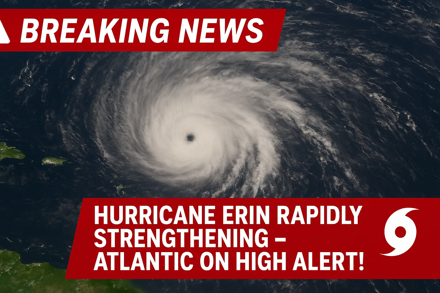
Breaking News: Hurricane Erin Rapidly Strengthening – Atlantic on High Alert!
Hurricane Erin: Meteorologists are tracking a vigorous tropical wave, currently labeled Invest 97L, that emerged from the west coast of Africa earlier this week. It is now moving westward over the Atlantic, and the National Hurricane Center (NHC) estimates there is a 90% chance it will develop into a named tropical cyclone within the next seven days. If it reaches tropical storm status, it will be called Erin, potentially the first hurricane of the 2025 Atlantic season.
🌪 Hurricane Erin – Live Update (19 August 2025)
- Current Status: Hurricane Erin is currently a Category 2 storm in the Atlantic.
- Wind Speeds: Sustained winds are being recorded at 105 mph (169 km/h).
- Movement: The storm is moving northwest at 12 mph (19 km/h).
- Location: As of the latest advisory, Erin is located about 600 miles southeast of Bermuda.
- Forecast Path: Models indicate Erin could strengthen into a Category 3 Major Hurricane within the next 24–36 hours as it moves over warm Atlantic waters.
- Threat Areas:
- Bermuda has issued hurricane watches, with tropical-storm-force winds possible by late tomorrow.
- The U.S. East Coast (particularly the Carolinas and Mid-Atlantic) remains under close monitoring, though a direct impact is still uncertain.
- Warnings:
- High surf and dangerous rip currents are expected along the East Coast from Florida to New York.
- Coastal flooding is possible in low-lying areas.
- Residents are advised to prepare emergency kits, check evacuation plans, and stay alert to official advisories.
⚠️ Threats & Hazards
- Caribbean Impact:
- Outer rainbands are causing heavy downpours, flash flooding, and landslides in Puerto Rico and nearby islands.
- U.S. East Coast:
- Swells and dangerous rip currents are expected along Florida to the Northeast by Monday–Tuesday.
- No direct landfall projected yet, but coastal impacts are highly likely.
⏱️ Next 24 Hours
- Erin will remain a powerful major hurricane.
- Track suggests it stays offshore but close enough to influence the Caribbean and East Coast waters.
🔥 Breaking Note (11:30 AM ET): Erin is now the strongest hurricane of the 2025 Atlantic season so far
🔴 Live Feed Begins
⏰ 9:00 AM ET – Hurricane Erin strengthens to Category 4, with winds at 145 mph. Rapid intensification underway.
⏰ 10:15 AM ET – Erin edges closer to Puerto Rico. Outer rainbands are hitting San Juan with heavy rainfall and gusty winds.
⏰ 11:30 AM ET – Erin upgraded to Category 5. Winds peak at 160 mph. Now the strongest hurricane of the 2025 Atlantic season.
⏰ 12:45 PM ET – Flash flood warnings issued across Puerto Rico & U.S. Virgin Islands. Residents urged to avoid travel.
⏰ 2:00 PM ET – Hurricane Erin is moving WNW at 14 mph, eye located 175 miles northeast of San Juan.
Swells are spreading to the Bahamas and the Florida coastline.
⏰ 3:30 PM ET – Officials warn of life-threatening rip currents along Florida beaches beginning late tonight.
⏰ 5:00 PM ET – Erin is expected to hold Category 5 strength overnight. Forecast models suggest a northward turn within 48 hours.
⏰ 6:45 PM ET – No U.S. landfall expected at this time, but East Coast coastal flooding and high surf remain likely.
⏰ 8:00 PM ET – National Weather advisories expanded:
- Puerto Rico – Tropical Storm Warnings
- Bahamas – Hurricane Watches issued
⏰ 9:30 PM ET – Erin’s eye wall is showing signs of slight weakening, but the storm remains extremely dangerous.
⚠️ Stay tuned for hourly tracking updates as Hurricane Erin moves across the Atlantic.
Why Erin Could Strengthen Quickly
Ocean temperatures along its projected path are unusually high for mid-August, averaging 28°C to 30°C (82°F to 86°F)—well above the 26.5°C threshold that fuels hurricane intensification. Additionally, wind shear (the change in wind direction and speed with height) is currently low to moderate, a favorable condition for development.
Long-range models indicate two main potential tracks:
- Northern Track – If Erin develops quickly and curves northward into the open Atlantic, Bermuda could face rough seas and strong winds, but the U.S. mainland might be spared.
- Southern Track – If development is slower, Erin could take a westward path toward the Caribbean, Bahamas, U.S. Southeast Coast, or even eastern Canada, increasing the risk of landfall and severe impacts.
- Iran USA War 2026: Military Reality, Oil Crisis, Economic Fallout, and How the Conflict Could End

- What Is Cockroach Janta Party? The Viral Satirical Movement Explaining a New Age of Internet Politics
- Iran War 2026: Operation Epic Fury Reshapes Middle East as Khamenei Falls
- Gold Is Rising at an Unusual Speed — Something Big Is Happening Globally?
- Elon Musk’s Next Big Move: AI, Space, or Robots?


Live Tracking & Updates: Hurricane Erin
Live Tracking & Updates: Hurricane Erin
Last Updated: 15 August 2025 – 09:00 UTC
Current Status
- Storm Stage: Tropical Storm Erin – expected to reach hurricane strength within hours
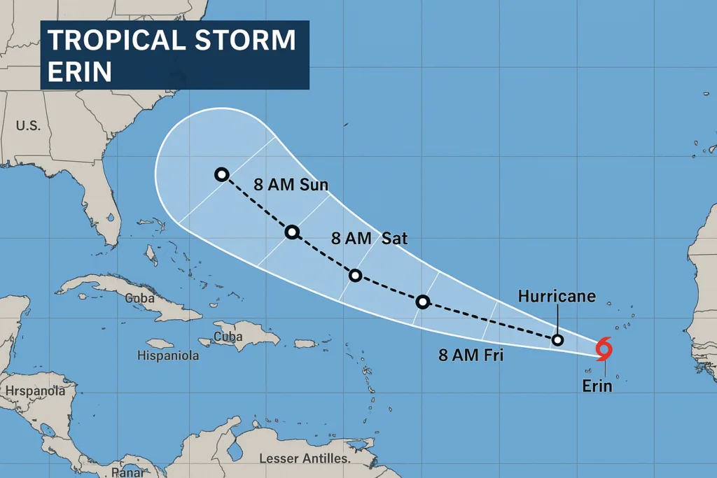
- Location: Around 520 miles east of the northern Leeward Islands
- Movement: West-northwest at 27 km/h (17 mph)
- Maximum Sustained Winds: 113 km/h (70 mph) – just below Category 1 hurricane level
- Sea Surface Temperature: 28–30 °C (82–86 °F) – highly favorable for intensification
- Wind Shear: Low – ideal for rapid strengthening
Forecast & Track Scenarios
- Erin is in a perfect environment for rapid intensification and could become a major hurricane (Category 3+) by this weekend, possibly reaching Category 4 with winds near 210 km/h (130 mph).
- Current model consensus places the storm’s center passing near or north of the northern Leeward Islands over the weekend.
- Possible future impacts to Puerto Rico, U.S. Virgin Islands, Bahamas, and Bermuda; U.S. East Coast risk still uncertain.
Impact Timeline (Subject to Change)
- Today (Fri): Transition from tropical storm to Category 1 hurricane.
- Sat–Sun: Rapid intensification to Category 3+; close pass near the Leeward Islands.
- Mon–Tue: Possible impacts on Bahamas, Bermuda, or U.S. East Coast depending on track shift.
Active Warnings
- Tropical Storm Watches are in effect for the Northern Leeward Islands, Puerto Rico, and the U.S. Virgin Islands.
- Marine advisories for dangerous surf and rip currents in the surrounding waters.
Preparedness Guidance
- Secure property and outdoor items now before winds increase.
- Have emergency supplies ready: food, water, medications, flashlights, batteries.
- Stay tuned to official weather bulletins every 6–12 hours.
- Avoid coastal waters—rip currents and large swells are already forming.
Past Named Erins for Context
- 1995: A Category 2 hurricane struck the Florida Panhandle.
- 2007: Tropical Storm Erin caused deadly flooding in Texas.
- 2013 & 2019: Short-lived tropical storms with minimal land impact.
Next Update: Planned in 6 hours or sooner if conditions change significantly.
Potential Risks If Erin Strengthens
While Erin is still thousands of kilometers from land, its future path remains highly uncertain. However, historical data show that storms forming in this region during August often have enough time to intensify into strong hurricanes.
If Erin reaches Category 3 or higher, possible hazards could include:
- Sustained winds exceeding 111 mph (179 km/h), capable of causing catastrophic structural damage.
- Storm surge flooding, especially along low-lying coasts.
- Inland flooding from torrential rainfall can occur even hundreds of miles from the storm center.
- Dangerous rip currents far from the storm’s center.
Current Warnings and Preparedness
No official watches or warnings have been issued yet because Erin is still in the pre-development stage. That said, authorities urge residents in hurricane-prone areas to:
- Review evacuation routes and local shelter locations.
- Prepare emergency kits with food, water, flashlights, batteries, and medical supplies.
- Secure property against high winds and heavy rain.
- Monitor reliable weather sources for official updates every 6–12 hours.
Historical Context for “Erin” Storms
The name Erin has been used for several past tropical systems, including notable ones in 1995 (a Category 2 hurricane that struck Florida) and 2007 (a severe tropical storm that caused deadly inland flooding in Texas). While names are reused unless retired for being particularly destructive, every storm is unique in path, strength, and impact.
If Invest 97L follows the most favorable development path, Erin could become a hurricane within the next 5–7 days. The coming week will be critical in determining whether this system curves harmlessly into the open Atlantic or heads toward populated coastlines.
I can now extend this with daily update bulletins tracking Erin’s progress and projected path, so you always have the most current information before it hits the headlines. Would you like me to prepare that?

Frequently Asked Questions: Hurricane Erin
1. What is Hurricane Erin right now?
At present, Erin is not yet a hurricane-it is an invest area of interest called Invest 97L, with a 90% chance of becoming a named tropical storm within a week.
2. Where is it located?
The system is currently in the eastern tropical Atlantic, a few hundred kilometers west of Africa, moving westward toward the central Atlantic.
3. When will it become a hurricane?
If conditions remain favorable—warm waters and low wind shear—Erin could reach hurricane strength in 5–7 days.
4. Which areas could be affected?
It’s too early for precise landfall predictions. Potential tracks include:
Turning north into the open Atlantic (minimal land impact).
Heading west toward the Caribbean, Bahamas, U.S. East Coast, or eastern Canada.
5. Why is it called “Erin”?
The World Meteorological Organization pre-assigns storm names from rotating lists. This year, Erin is the next name scheduled for the Atlantic basin.
6. Is there any warning issued?
No official watches or warnings have been issued yet. Warnings will only be released if Erin moves closer to land and poses a direct threat.
7. How strong could it get?
It’s too early to say, but with sea surface temperatures above 28°C and favorable atmospheric conditions, it has the potential to become a major hurricane (Category 3+).
8. What should residents do now?
People in hurricane-prone areas should:
Review evacuation routes.
Prepare emergency kits.
Stay updated through official forecasts every 6–12 hours.
9. Has there been a Hurricane Erin before?
Yes. Past storms named Erin have varied from minor systems to damaging hurricanes, such as the 1995 Erin that struck Florida.
10. How often do storms form in this part of the Atlantic in August?
Historically, mid-August marks the start of the hurricane season peak, when conditions are most favorable for strong, long-lived storms.

Author


TheAshNow Team At TheAshNow, we're a team of passionate researchers, writers, and digital creators dedicated to bringing you well-researched, insightful, and engaging content on topics that matter—from trending tech to lifestyle, digital detox, Home Gardening, education, biographies, and beyond. Every article is crafted with authenticity, backed by facts, and designed to empower your daily life with practical knowledge.
Join thousands of smart readers who trust TheAshNow for quality content that inspires.Our Ventures:
🔹 TheAshNow — News & Magazine
🔹 TheAshNow AI — Automation System
🔹 TheAshNow Invitation — Digital Invitation
🔹 TheAshNow Partner Program
🔹 TheAshNow Featured Profiles — Global Leadership
🔹 TheAshNow Tools — Free Tools
🔹 TheAshNow Services — Digital Services
🔹 TheAshNow Group — All Ventures
🔹 TheAshNow Shop
🔹 TheAshNow Bharat — Hindi News
🔹 TheAshNow Study📌 Follow us on LinkedIn, Facebook, Instagram, Threads, WhatsApp, X (Twitter), and YouTube for more updates!


[…] Breaking News: Hurricane Erin Likely to Form – Atlantic on Alert Rewire Your Brain with Digital Silence: Boost Focus & Calm […]
[…] Breaking News: Hurricane Erin Likely to Form – Atlantic on Alertby TheAshNow Team […]